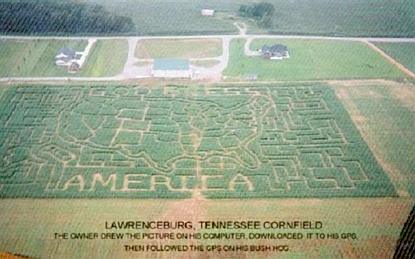
What a splendid image, what a worthy use of time!
I hope people are able to see it as they fly over what they presume to be the nothingness between New York and Los Angeles.
Click on the image to see an enlargement. The whole thing is too large for our post width.
I found it at the Kaitlyn Mae Book Blog.

7 comments:
I'll show you crop circles! How's dem crop circles!
That's excellent. How long before some ecoworrier comes along complaining about the destruction of food that could be used to feed starving africans?
God I love Americans!
Any European trying a stunt like that would be a laughing stock for all eternity.
Over here, beeing a patriot is one thing, loudly expressing yourself as one is quite another.
You have to be both a farmer AND a geek to do that. I hope he had one of those talking GPSs - you have to look at mine, and it would have been really difficult to follow the track.
A remarkable effort. I hope it is under the jet routes.
The owner (John Rose) made this maze in 2002. He got a mapping professional to help him. The detailed procedure is outlined in a paper partway down this page:
link
Note the software program he used is called "Fugawi". That's an old Boy Scout joke about the Fugawi tribe of Indians, who would call out to one another on a hunt "where the Fugawi?"
Wally,
Many thanks for the research! Now we know the details.
Now that is an AMERICAN I am certain I could really like, obviously proud of his country, and what a nice unusual way of showing it.
newgame
Post a Comment