Here’s the account from ANSAmed:
Mideast: France to Provide Pre-1967 Border Maps
Beirut, July 17 — During the indirect talks between Israel and Syria under way with the mediation of Turkey, France offered its own archives of geographical maps belonging to the period of French Mandate of Syria (1920-1946), London-based pan-Arab daily al-Hayat reported today, specifying that on the basis of these maps the claims of Damascus on the eastern coast of the Sea of Galilee, main Israeli drinking water reserve, could be contested.
Quoting French diplomatic sources, the daily adds that after the French-Syrian summit held in Paris on Saturday “President Nicolas Sarkozy asked the foreign ministry to provide Turkey with the maps of the Syrian borders during the French Mandate because the Syrian-Israeli border of June 4, 1967, claimed by Syria, is different from the international one between Syria and Palestine of 1923”.
In exchange of peace with Israel, Syria asks for complete restitution up to the line of June 4 of the Golan Heights, occupied by Israel during the second Arab-Israeli War which broke out on June 5, 1967. In Israel the legitimacy of the claim of Syria is contested, affirming that the only border between the two countries still today recognised internationally is the one marked by France and the United Kingdom in 1923. Except from this line, according to the border in force since the armistice of 1949 until June 4, 1967, Syria enjoyed a total control on the eastern coast of the Sea of Galilee.
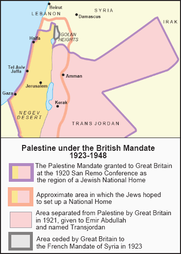
So what is the issue with the borders of the French Mandate of Syria? I located a map at PASSIA that shows the territorial difference after Britain’s adjustment with France.
- - - - - - - - -
[The Palestinian Academic Society for the Study of International Affairs (PASSIA) was founded in March 1987 by Dr. Mahdi Abdul Hadi and by a group of Palestinian academics and intellectuals in Jerusalem — Al-Quds Al-Sharif. “60 Years Since The Nakba.” Funded in part by the Ford Foundation, the Rockefeller Foundation, the American Embassy, and the British Embassy. I recommend a visit to their website.]

If you want the larger version, download the full-sized PASSIA map here (pdf format).
As you can see from this map, the important area is the little piece of territory to the northeast of the Sea of Galilee that was ceded to the French by the British in 1923. It overlaps part of what is known as the Golan Heights.
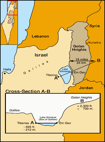
The map is not detailed enough to show it, but a comparison with the one below gives you an idea of the strip of territory that’s involved: the little bit of dry land on the far side of the Sea of Galilee, which Syria had shelled with impunity during the years leading up to the Six-Day War.

The French Mandate of Syria arose out of the Sykes-Picot Agreement, an understanding reached between Britain and France during the Great War. After Britain ceded the area, the French Mandate reached all the way to the northeastern corner of the Sea of Galilee.
But the pre-1967 boundary between Israel and Syria was slightly different, and included that narrow, demilitarized, and undefendable littoral at the foot of the Golan Heights. I’m guessing that Syria is going to claim precedent based on the borders of the French Mandate, and demand a return beyond the 1967 borders all the way to the Sea of Galilee.
Why bother doing that? Two possible reasons occur to me:
| 1. | Always ask for more than you expect to get. By demanding a return to 1923 border, Boy Assad would appear generous and magnanimous when he “compromises” on the 1967 border. | |
| 2. | Olmert looks like he is ready to give the Arabs anything they ask for. All indications are that the Israeli Prime Minister is willing to surrender anything the Arabs have ever demanded, and ask for virtually nothing in return. The latest word is that he’s ready to cut a deal on the Shebaa Farms as well as the Golan Heights. So why not ask for more? The 1923 border could be the next demand after Shebaa Farms. Because as far as the Arabs are concerned, there’s always another demand, until the Jews sleep with the fishes and Israel is no more. |
The really big question, however, is this: What does Nicolas Sarkozy think he’s doing? His recent antics have shown that he’s more than eager to play footsie with the Arabs, all for the sake of the Mediterranean Union and the larger interests of the mandarins of the EU.
Brussels is worth a map.

Hat tip: insubria.

6 comments:
Clearly the French move is an attempt to broker a compromise, in which Israel and Syria would accept the 1923-48 border rather than the 1948-67 border, and Israel would retain a narrow coastal littoral around the east side of the Lake Kinneret/Sea of Galilee. I don't see anything particularly sinister or underhanded about it.
Now whether Israel should accept such a peace deal, resulting in an "undefendable" coastal littoral around the Sea of Galilee with the current Syrian regime in control of the heights above, is another matter entirely.
This may be about water rights. The Kinneret is the largest source of fresh water in Israel. I can not imagine willingly giving the Syrians access to it.
Momteachs --
Of course! How could I have forgotten water, the single most important strategic issue of the area?
Thank you for your insight.
All I can state in response to this genocidal move - and that is what it is --is that God is the judge of the nations and he does so throughout history: France will have hell to pay. To restate a phrase from The Outlaw Josey Wales: "Heaven is coming for breakfast." And I think the French will prefer the peace of Hell.
Sarkozy is playing Vichy to the Muslims. He is collaborating as did WWII France in turning the Jews over to their murderers.
Equally, then, the Israeli's can claim all of the British Mandate under similar, more just, claims.
The problem is for the Arabs by bringing this up, it brings up the whole issue of there is already a two state solution. Which is where I think the debate should be.
The problem is for the Israeli's, the current leaders do not have the backbone to argue justly for their rights.
Post a Comment